Treescape Typology for Great Britain

A 'treescape' is a landscape containing woody features, which have ecological functions similar to woodlands. They include natural woodland, managed forests, trees outside of woodland and woody linear features. In Great Britain, we have good quality data on woods and forests, but we lack assessment of the whole treescape to understand its character and value. Through the Connected Treescapes project we created a typology to categorise the GB treescapes into 14 distinct types. 

Our GB Treescape Typology represents an entirely new way of describing and understanding treescapes. It can be used to:

  • Support natural capital assessment and ecosystem service valuation;
  • Inform spatial decision-making;
  • Contribute to new insights into the social and cultural values of our trees and woodlands. 

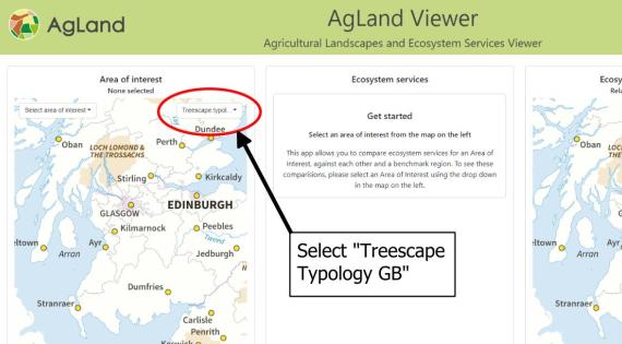
View an interactive version of the GB Treescape Typology on the AgLand Viewer. (When in the AgLand Viewer, select “Treescape Typology GB” in the left hand map).

Scroll down this page to see Methods and Descriptions of the GB Treescape Typology.

Typology Map GB
Typology Map GB

Method

We brought together 45 variables from 15 datasets treescape features, including quantity (e.g. woodland cover, tree cover density), quality (e.g. area of ancient woodland) and configuration (e.g. woodland patch size and connectivity) of treescapes with abiotic variables relating to climate, soil and topography. This included data on natural woodlands, managed forests, trees outside of woodland and woody linear features, which together form the whole ‘treescape’. We undertook clustering and dimensionality reduction using Self-Organising Maps (SOMs), which is an artificial neural network method to simplify and visualise complex data by reducing its dimensionality and grouping similar units into clusters, referred to as ‘nodes’ using the Kohonen R package. We ran 1000 iterations and selected clusters with >80% consistency. Analysis was carried out for all squares in Great Britain with <1% woodland cover.

Overview of the input variables and method used to create the typology

Creation of the treescape names

In order to come up with simple descriptions that adequately described the classes, and enabled related classes to be distinguished, we (i) examined the variable importance plots to identify key distinguishing variables for classes, (ii) examined the summary boxplots of the raw data to help describe distinguishing variables, and (iii) undertook exploratory cluster analysis to help describe critical differences between classes in a hierarchical way. In order for the model to run, we converted all the missing values (e.g. number of coniferous patches, when conifer cover was zero) to zero.

We used ‘rcart’ from the ‘rcart’ package in R to explore these clusters. We clustered the overall classes with all the variables directly focused on the treescapes, i.e. excluding broadly environmental variables such as elevation, NDVI etc. so that we could explore the distinct characteristics of these classes. In order to explore specific groups of similar classes in more detail, we ran the clustering with specific sets of classes alone to help discern the important differences between smaller groups. From this we created names and descriptions for each treescape. Below is a simplified version of the results of hierarchical clustering of the categories derived from the self-organised mapping analysis. It was produced to simply explain the relationships and differences between the treescape categories. 

Diagram showing naming process of typology
Summary of the clustering of the treescape typologies

Treescape definitions

Broadleaved woodland

These treescapes are dominated by deciduous woodland (median > 10%) which may be in fewer larger patches, or more scattered.

W1: Broad-leaved wooded treescape

Treescape with very high levels of broadleaved woodland cover, typically in 1-2 large patches.  Ancient woodland occurs at high cover (23-54%). Ancient trees scarce, but more abundant than in any other treescape class (95 percentile = 29).

Occurs locally across GB, but especially places like Wye Valley, southern Lake District, Snowdonia, New Forest and parts of Kent and Sussex. Occurs on a range of soil types. Both the soil type and the dominant tree species will influence the overall woodland ecosystem.

W2: Mixed wooded treescape

Treescape with high levels of tree cover, comprised of a mixture of both broadleaved and coniferous woodland. Broadleaved woodland cover is high (11-29%) but fragmented (3-9ha each, in 2-5 patches), but coniferous woodland cover tends to be higher (18-47%) in fewer, larger patches (6-26ha each, in 2-3 patches).

The broadleaved woodlands in W2 tend to be in smaller blocks than W1, W3 or W4 and consequently it has lower broad-leaved woodland cover than W1, W3 or W4. The coniferous woodland blocks of W2 tend to be larger than its broadleaved woodland blocks, and they are larger than in C3 or C4. Has a very variable amount of ancient woodland (0-36%), but tends to be much lower than W1, and slightly higher than W3 and W4.

Locally frequent in major glens in eastern Scotland. Scattered elsewhere, but especially in central southern England and Wales.


W3: Moderately wooded in more tree-filled landscape

Treescape with high levels of broadleaved woodland, which is distributed in several patches, with a high length of woody linear features. Has a relatively high area of ancient woodland (2-21%; overall similar to W2).

W3 and W4 tend to have larger broadleaved woodland patch size than W2, and smaller, less cohesive patches than W1. W3 tends to have similar broadleaved woodland cover as W4 (29% v. 25% for W4), but longer length of woody linear features (2400m median for W3, 800m median for W4), and thus W3 has a substantially higher total tree cover density (19-29% v. 11-20%).

Tends to be most frequent in heavily wooded areas of southern England. Dominant broad land cover tends to be grassland (but also broad-leaved woodland and arable).

W4: Moderately wooded in more open landscape

Treescape with high levels of broadleaved woodland, which is distributed in several patches, but with a low length of woody linear features. Has a relatively high amount of ancient woodland compared to C or T treescape classes, but lower than other W classes (2-16%).

W3 and W4 tend to have larger broadleaved woodland patch size than W2, and smaller, less cohesive patches than W1. W3 tends to have similar broadleaved woodland cover as W4 (29% v. 25% for W4), but longer length of woody linear features (2400m median for W3, 800m median for W4), and thus W3 has a substantially higher total tree cover density (19-29% v. 11-20%).

Tends to occur on the upland fringes of Wales and northern England and scattered across Scotland away from the uplands. Tends to be found on organic soils with free drainage. Dominant landcover is grassland.

Conifer woodland

Tree cover in these treescapes is dominated by conifer woodlands (from low to very high cover: 5-70%). There is little to no broadleaved woodland.

C1: Conifer-dominated landscape at very high density

Almost complete cover of coniferous woodland (67-95%). This treescape type usually occurs in contiguous blocks, often mixed together with C2.

Very similar to C2, although area of felled land is very low (0-16%) and area of young trees (0-13%) is higher than C2. These data come from a single year, so in reality C1 and C2 probably represent different stages in dynamically-managed conifer plantations.

C1 and C2 dominate in Southern Uplands/Kielder Forest, frequent elsewhere in Scotland, especially north and west of Glasgow, smaller blocks in North York Moors, the uplands of Wales and Thetford Forest in East Anglia. Typically (although not always) occurs in areas of high rainfall, high elevation, and deep peat or organic wet soils.

C2: Conifer-dominated landscape at high density

Almost complete cover of coniferous woodland (61-95%). This treescape type usually occurs mixed together with C1.

Very similar to C1, although area of felled land is higher (28-53%) and area of young trees (0-6%) is lower than C1. These data come from a single year, so in reality C1 and C2 probably represent different stages in dynamically-managed conifer plantations.

C1 and C2 dominate in Southern Uplands/Kielder Forest, frequent elsewhere in Scotland, especially north and west of Glasgow, smaller blocks in North York Moors, the uplands of Wales and Thetford Forest in East Anglia. Typically (although not always) occurs in areas of high rainfall, high elevation, and deep peat or organic wet soils.

C3: Conifer woodland stands in open semi-natural landscape

Moderate cover of coniferous woodland (5-27%) in 1-2 small patches (2-17ha).

The tendency of slightly larger patches results in a moderate overall tree cover density (5-19%), which is much higher than C4. Subtle differences determined from clustering analysis indicate that: felled areas are particularly scarce (0-2%), and cohesion of conifer patches tends to be slightly higher than in C4 (87-97).

Frequent in upland areas of GB – across Scotland, Pennines, North York Moors, Peak District, central Wales and the upland regions of south-western England. Includes native Scots pine woodland. Tends to occur in semi-natural land cover types, and in places that are upland, with deep peat or organic wet/free-draining soils.

C4: Scattered conifer patches in open semi-natural landscape

Low to moderate cover of coniferous woodland (2-20%) in 1-2 small patches (1-13 ha).

The tendency of slightly smaller patches results in a low tree cover density (0.3-4%5-19%), which is much lower than C3. Subtle differences determined from clustering analysis indicate that: felled areas are scarce, but when felling has occurred it tends to be higher than C3 (0-6%), and cohesion of conifer patches tends to be slightly lower than in C3 (81-96).

Occasional in upland areas of GB. Includes native Scots pine woodland. Tends to occur in semi-natural land cover types, and in places that are upland, with deep peat or organic wet soils.

Other treescapes

These treescapes are more open than W or C. They are ordered according to their total tree cover density.

T1: Well-connected treescape with abundant small woodlands 

Broadleaved woodland area is moderate (7-15%, similar to T2), but is distributed in more (4-6), smaller (1.4-2.8 ha) patches of broad-leaved woodland, and with a very high length of woody linear features (2.1-4.3km) providing good connectivity. Orchards are more frequent in T1 than any other category, albeit still very rare (95% percentile = 2%).

T1 and T2 tend to have more broad-leaved woodland patches and more broad-leaved woodland area than T3-6. They also have a greater length of woody linear features than T3-5 (although T6 is similar). T1 has more, smaller broad-leaved woodland patches and slightly more woody linear features, leading to a slightly higher overall tree cover density (7-14%).

Mostly in lowland England. Tends to occur on heavy clay and medium loamy soils. Dominant land cover types are grassland and arable. 

T2: Well-connected treescape with few, large woodlands

Broadleaved woodland area is moderate (6-15%, similar to T1), but is distributed in fewer (3-5), slightly larger (1.6-4.0 ha) patches of broad-leaved woodland, and with a high length of woody linear features (1.6-4.0km) providing good connectivity.

T1 and T2 tend to have more broad-leaved woodland patches and more broad-leaved woodland area than T3-6. They also have a greater length of woody linear features than T3-5 (although T6 is similar). T2 has fewer, slightly larger broad-leaved woodland patches and slightly fewer woody linear features, leading to a slightly higher overall tree cover density (7-14%). T2 has a higher area of ancient woodlands than any other T category (0-5%).

Mostly in lowland Wales, west country and north west England. Tends to occur at slightly higher elevation than T1, on medium loamy soils, mostly in grassland land cover types.

T3: Moderately connected treescape with few, large woods

Broadleaved woodland area is moderate-low (3-10%). The broad-leaved woodland is distributed in a small number (1-3) of large patches (1.8-4.9 ha), and with a high length of woody linear features (1.0-2.9km).

Lower area of broad-leaved woodland than T1 or T2, but tends to be higher than T4-6. The broad-leaved woodland patch size tends to be larger than all other T categories.

Scattered throughout rural lowland Britain, and found in similar places to T4. Tends to occur in heavy clay, medium loamy, and shallow mineral soils. Tends to be most abundant in arable-dominated landscapes (but also in grassland).

T4: Moderately connected treescape with few, small woods

Broadleaved woodland area is low (2-7%) and distributed in a small number (2-3) of small patches (1.1-2.6 ha), and with a moderate length of woody linear features (0.7-2.4km).

Compared to T3, tends to be slightly less tree-filled in all measures: fewer, smaller woodlands, with fewer hedgerows and overall lower tree cover density, although there are overlaps with T3. Ancient woodland is scarce in all T categories, but is particularly scarce in T4 and T6 (95% quantile = 3% and 2% respectively, whereas >9% for all other T categories). T4 is also similar to T6, but T4 tends to have slightly higher woodland cover with woods less isolated from each other, and much lower length of woody linear features.

Scattered throughout the rural lowlands, and found in similar places to T3. Tends to be most abundant in arable-dominated landscapes, but is also the dominant treescape within urban land cover type.

T5: Open landscape with few woods

Broadleaved woodland area is low (2-9%) with few (2-4), small (1.1-2.9ha) woodlands and a low length of woody linear features (0.2-1.4km).  

The median length of woody linear features is less than half any other T category. The broad-leaved woodland is distributed in a small number (2-3) of small patches (1.1-2.6 ha), and with a moderate length of woody linear features (0.7-2.4km).

Predominantly in the coastal lowland plain in eastern Scotland and north-eastern England. Tends to be in grassland or arable land cover type.

T6: Sparsely wooded, hedgerow-dominated treescape

Broad-leaved woodland area is consistently low (2-3%) with few (2-3), very small (0.7-1.3ha) and isolated (nearest neighbour: 200-550m) woodlands, but with a high length of woody linear features (1.7-4.0km).

Any woodlands tend to be smaller and isolated compared to all other T categories (median nearest neighbour = 350m, v. 160-180m for all other T). Median length of woody linear features is similar to T2, so less than T1, but far more than T3-T5.

Scattered throughout rural lowlands, especially across most of England. Tend to be in arable and grassland land cover.

Image
typology selection on AgLand Viewer

Treescape visualisation

The Treescape Typology has been added to the AgLand Viewer for visualisation. To view the treescape typology select “Treescape Typology GB” from the drop down menu in the top right corner of the map on the left hand side of the webpage. More information on the AgLand Viewer and the other data layers it contains is available on the info tab on the AgLand Viewer.

The typology will be made available at as a downloadable dataset at a later date. 

Acknowledgements

The Treescape Typology was produced by Merryn Hunt, Lindsay Maskell and Michael Pocock (UKCEH).

Input and advice was provided by Cecily Goodwin and Diana Bowler (UKCEH) and Piran White, Jane Hill, Charles Cunningham and Colin Beale (University of York). Jon Cooper (UKCEH) implemented the typology in the AgLand Viewer that was developed as part of the AgLand project.

This is an output of the Connected Treescapes project, led by the University of York.

The research is funded through the UKRI Future of UK Treescapes Research Programme, supported by the Natural Environment Research Council (NERC), the Economic and Social Research Council (ESRC) and the Arts and Humanities Research Council (AHRC), with additional support from UK Government bodies: the Department for Environment, Food and Rural Affairs (Defra), Forestry Commission and the Scottish and Welsh Governments.

Principal Investigator

Michael works with the teams researching land use and biodiversity change for this project.
Merryn Hunt
Research Associate - Earth Observation Data Scientist
  • Analysis of national datasets (e.g.Countryside Survey) to test hypotheses, report on stock and change of Natural Capital, attribute changes in ecosystems to drivers such as invasive species and atmospheric deposition, 2001 to present.
  • Work Package Leader (WP) on Habitats for Glastir (agri-environment) monitoring in Wales 2012-present
  • Survey management and method development (Countryside survey and Glastir)