20.05.2022

We’re delighted to take part in this year’s European Geosciences Union General Assembly (EGU22) with contributions from our hydro-climate risks, water resources, soil and land use, and atmospheric chemistry and effects science areas. This year’s event (23-27 May 2022) is hybrid, taking place in-person in Vienna as well as online. Read on for more information on the science we’re sharing...

The EGU general assembly, one of the world’s largest science conferences, looks at all aspects of earth, planetary and space science. It’s also a place for networking and support, for example with resources and workshops for early career researchers or discussion on science communication. 

This year, UKCEH scientists will be presenting details of innovative and applied research that addresses fundamental challenges such as reducing flood impacts, forecasting drought risk and understanding climate change impacts around the world.

We will spotlight recent work bringing significant improvements to rainfall and climate modelling and more accurate flood forecasting. Some of this work, delivered with international partners, has already been trialled with real-world outcomes that are helping to protect lives and property.

We’ll also discuss new good practice guidance for drought monitoring globally and details of the ROBIN project to create a global network of river basins suitable for detecting climate-driven trends.

Other UKCEH-led presentations will highlight research on the likely future of global wildfires, approaches to improving soil moisture modelling, and effects of natural flood management interventions on water quality. See links to all these presentations below. Elsewhere, partners including the University of Innsbruck, University of Exeter, University of Reading and the Met Office will provide updates on research involving UKCEH scientists.

Our senior hydrometric scientist Nick Everard is convening three sessions. Two of these bring hydrometry to the fore:

And a third Great Debate session will examine the role of the earth science community in responding urgently to the extreme challenge of climate change:
UKCEH oral presentations

Monday 23 May

Steven Cole, Nowcasting flood impacts of convective storms in the Sahel (session HS4.1)

  • Flash flooding from intense rainfall results in major damage and loss of life in Africa. Extreme storms in the Sahel region are increasing in frequency under climate change and the impacts of flash flooding are likely to worsen. This talk will discuss work to co-develop an early warning system for Senegal, incorporating nowcasting of heavy rainfall likelihood and flood risk from intense convective storms at city and sub-national scales. Operational trials in the 2020 and 2021 rainy seasons, and during intensive nowcasting testbeds with researchers and forecasters, has shown how these new nowcast products support impact-based forecasting.

Tuesday 24 May

Doran Khamis, Data-driven modelling of soil moisture: mapping organic soils (session ITS2.6/AS5.1)

  • Improving our understanding of soil moisture is crucial for flood prediction, smart agriculture, modelling nutrient and pollutant spread and evaluating the role of land as a sink or source of carbon and other greenhouse gases. Soils rich in organic matter – key to understanding the role of the land in achieving net zero carbon – are not well modelled in land surface models. This talk discusses an approach to soil moisture modelling developed from the COSMOS-UK sensor network, and how the soil moisture time series can be used to predict soil carbon.

John Robotham, Natural flood management features mitigate sediment and nutrient loading in a lowland agricultural catchment in England (session HS5.7)

  • This talk describes a study assessing the ability of natural flood management (NFM) features to trap potential pollutants in run-off from agricultural catchments. The results of this water quality monitoring demonstrate the potential of NFM interventions to provide additional value by mitigating diffuse pollution in lowland catchments.

Cornelia Klein, Combining CMIP data with a convection-permitting model and observations to project extreme rainfall under climate change (session CL2.4)

  • Using the Sahel region in West Africa as a case study, this talk highlights research to provide more realistic projections of extreme tropical rainfall under climate change while at the same time allowing better risk communication to stakeholders. Researchers combined rainfall projection from a high-resolution model for the continent with a large number of traditional climate models and ‘observational’ data. Such data comprised information on cloud formations and rainfall intensities obtained by satellites, as well as moisture and wind measurements.

Julia Drewer, Diversifying understory vegetation and riparian restoration as ecological management options to regulate greenhouse gas fluxes in oil palm plantations (session BG3.19)

  • Oil palm plantations have replaced large areas of forest in the tropical landscape of Southeast Asia and are major emitters of greenhouse gases (GHGs). However, within established plantations there are management options which may reduce these emissions, including altered management practices within plantations and restoring forest within the landscape. Managing the vegetation within and around plantations could potentially minimise environmental damage and maximise co-benefits such as soil protection, pest control and support for biodiversity. The impact of these management practices is uncertain, and there is a real need for an evidence-base to guide improvements in the environmental sustainability of oil palm plantation management. Here we present GHG fluxes from two long-term experiments as part of ‘The Biodiversity and Ecosystem Function in Tropical Agriculture’  project.

Janice Scheffler, Local physical chemistry statements for low cost sensor added value (session AS3.1)

  • Air quality monitoring with a high spatial and temporal resolution is essential to understand the sources, processes, and impacts of air quality  on human health and the environment, especially in densely populated urban areas. Current state-of-the-art instruments don’t allow for such a high spatial resolution monitoring due to costs. Low cost sensors provide an opportunity to bridge this divide but studies suggest they have a problem with accuracy at high relative humidities and for varying Particulate Matter (PM) composition. This talk presents a comparison of low cost sensor PM2.5 concentrations with measured and calculated total PM2.5 concentrations from reference instruments for time periods with different air quality characteristics. It discusses the physico-chemical characteristics leading to varying results of low cost PM sensors.

Chris Taylor, Nowcasting tracks of severe convective storms in West Africa from observations of land surface state (session CL4.1)

  • Nowcasting provides essential alerts of extreme events several hours ahead. Working with West African Met Services, we developed a system to improve very short term forecasts (hours) of severe convective storms. Using information about how wet the soil is, we were able to extend the period the period that forecasters can predict the tracks of these storms by several hours. This pilot study demonstrates potential for early warning systems of flash flooding, which are extremely damaging and becoming more frequent under climate change.

Lucy Barker, Supporting national reporting of drought hazard, exposure and vulnerability to track progress in drought adaptation, mitigation and management (session NH9.6)

Image
Cover of Good Practice Guidance for national reporting on UNCCD strategic objective 3
  • Droughts are one of the most damaging and costly natural hazards. Proactive drought management is crucial to mitigate their widespread primary and secondary impacts. For this we need to understand the drought risk in terms of the characteristics of the drought hazard, who or what is exposed to the drought hazard, and who or what is vulnerable to the effects of drought. This talk provides an overview of new guidance for Parties to the UN Convention to Combat Desertification to report their progress in enhancing the resilience of vulnerable populations to drought. The guidance is demonstrated using two contrasting case studies for the UK and Thailand while key areas to improve drought risk assessment at the global scale are highlighted.

Wednesday 25 May

John Wallbank, Dual-polarisation X-band radar estimates of precipitation assessed using a distributed hydrological model for mountainous catchments in Scotland (session HS7.2)

  • Making robust observations of precipitation patterns in mountainous terrain is a major challenge with practical importance. This talk explores a way to address this challenge by improving observations of precipitation made by weather radar. Here, a set of Quantitative Precipitation Estimates (QPE) - obtained from an observation campaign using the National Centre for Atmospheric Science’s mobile X-band dual-polarisation Doppler weather radar in a mountainous area of northern Scotland - are assessed with reference to observed river flows. Each form of QPE is used as an input to the Grid-to-Grid distributed hydrological model used for flood forecasting across Great Britain, and the simulated river flows compared to observations. The hydrological assessment reported on here has the benefit of integrating the precipitation over space and time which serves to complement and extend a previous meteorological assessment using raingauge data alone.

Douglas Kelley, Likely future(s) of global wildfires (session BG1.2)

  • This talk discusses likely substantial increases in burning by 2100 in boreal and tropical forests irrespective of future emissions and after accounting for the (often considerable) uncertainties and biases in global fire and climate modelling. Northern Siberian forest and permafrost will see the worst increase, with extreme fire seasons becoming up to 20 times more frequent. Amazon and Indonesia forest and peat will also likely see increases. These are carbon rich ecosystems, and fire will likely release much more greenhouse gases, exacerbating global warming. The recent UNEP report informed by this research provides recommendations for combating this increased threat of wildfire, including shifting funding priorities to landscape management and fire reduction, and post-fire people and infrastructure recovery.

Bethan Harris, Satellite-observed vegetation responses to intraseasonal rainfall variability (session HS6.7)

  • How vegetation responds to changes in rainfall is a key factor in understanding terrestrial water availability, as well as land-atmosphere feedbacks that can occur as a result of changes in evapotranspiration and albedo. Here we assess the relationships between the within-season variability of rainfall and vegetation across the tropics and mid-latitudes. Vegetation Optical Depth (VOD), derived from satellite observations and used as a proxy for plant biomass and water content, responds to intraseasonal precipitation variability in arid and semi-arid regions. Improving this understanding could help decision-making in water management or agriculture as well as improving dynamic vegetation modelling for land surface models.

Thursday 26 May

Jonny Jovani, CH4 and N2O emissions from smallholder agricultural systems on tropical peatlands in SE Asia (session BG3.27)

  • Few studies have measured GHG emissions from smallholder agricultural systems in tropical peatlands, or non-CO2 emissions from human-influenced tropical peatlands more generally. The aim of this study was to quantify CH4 and N2O fluxes from agricultural landscapes on tropical peatlands in SE Asia and assess their environmental controls. The study was carried out in four peatland areas in Malaysia and Indonesia.

Friday 27 May

Joshua Talib, MJO-induced land-atmosphere feedbacks across East Africa (session AS1.20)

  • The Madden-Julian Oscillation (MJO) is an eastward-propagating atmospheric wave which substantially controls sub-seasonal tropical rainfall variability. In this talk we discuss how MJO-induced precipitation anomalies promote a surface response that feeds back onto local and regional atmospheric conditions. Across semi-arid regions of East Africa, surface soil moisture and turbulent fluxes respond to MJO-induced anomalous precipitation. Spatial variations in the surface response to the MJO across the Turkana channel, feeds back onto the intensity of the Turkana jet. Surface-induced Turkana jet variations influence the daily cycle of precipitation across Kenya. This work is the first to highlight the importance of surface soil moisture in controlling Turkana jet characteristics and precipitation across East Africa

Stephen Turner, ROBIN - A Reference Observatory of Basins for INternational hydrological climate change detection (session HS2.5.1)

  • Floods and droughts may become more severe in a warming world. To adapt to future changes in water quantity and regimes, we need to detect and attribute emerging trends in hydrological variables such as river flow, and we require updated projections of future flood and drought occurrence. To detect climate-driven trends we need to analyse river basins that are relatively undisturbed by human impacts. Recognising this, some countries have declared 'Reference Hydrometric Networks' (RHNs) of locations where river flows are measured, and where human impacts are absent or minimal. However, to date there have been no efforts to integrate these globally. With the ROBIN initiative, we are now advancing a truly worldwide effort to bring together a global RHN.

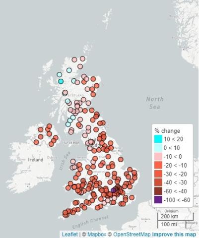
Jamie Hannaford, enhanced future FLows and Groundwater (eFLaG): future hydrological projections to enhance drought resilience in the UK (session HS2.4.4)

Image
Map of UK with dots of locations
  • Water resource managers all over the world require timely and robust climate projections to support planning on a range of timescales. In the UK, water companies are obliged to produce long-term water resource management plans to ensure security of water supply, and these are required to take account of climate change. One of the challenges is having ready access to the latest climate projections, at an appropriate scale to support regional- and national-scale planning. In particular, a major gap has been the availability of a national, spatially-coherent dataset of river flows and groundwater projections. efLAG provides a consistent, spatially coherent national dataset of future hydrological projections (river flow and groundwater) based on the latest UKCP18 climate projections and using a range of models to allow users to consider uncertainty.